Impact
The impact of Tropical Storm ANA could reach windspeeds up to 80km/h and rainfall up to 150mm/24h, with 360mm/24h reported in some parts of Malawi.
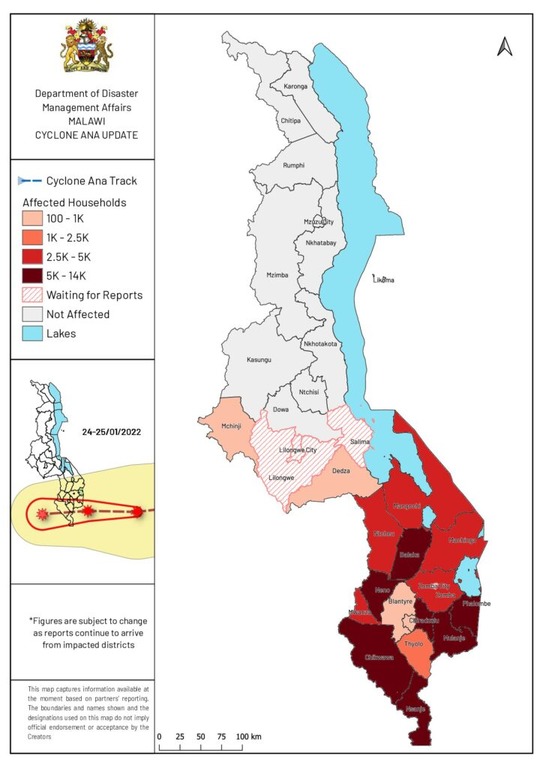
According to various sources, a total of 91 deaths have been reported so far with 392,367 people affected:
| Country |
|
Deaths |
People Affected |
| Madagascar |
|
41 |
c. 130,000 |
| Mozambique * |
|
18 |
45,395 |
| Malawi ^ |
|
32 |
216,972 |
| Zimbabwe |
|
None reported |
None reported |
| TOTAL |
|
91 |
392,367 |
* UN Office for the Coordination of Humanitarian Affairs (OCHA)
^ Republic of Malawi, Department of Disaster Management Affairs (DoDMA) as of 26 January 2022 and 30 January 2022
However, a lack of comprehensive information and low news coverage is proving to make it difficult to understand holistically the full impact of the recent storm in the area.
International and Government Agencies
The storm has the potential to affect “highly vulnerable populations who have already recently suffered from natural disasters and conflicts in northern Mozambique” – UN Office for the Coordination of Humanitarian Affairs (OCHA)
“Beyond the emergency response we need to make sure that we support those families to rebuild their livelihoods — their fields are submerged and their houses are destroyed … we need to support them to build back safer.” – Naemi Heita, International Federation of the Red Cross and Red Crescent Societies
“Meanwhile, DoDMA is facilitating the process of restoring power to medical establishments; water treatment and distribution systems; schools and other areas with similar attributes… DoDMA is also working in collaboration with the MDF (Malawi Defence Force) and other stakeholders to reach out to cut-off areas with relief assistance.” – Charles Kalemba, Commissioner for Disaster Management Affairs, Office of the President and Cabinet, Republic of Malawi
Climate Change
Southern African countries have been repeatedly struck by severe storms and cyclones in recent years, which experts say are worsening as waters warm due to the climate emergency.
3 storms hit the region in 2019 alone, starting with Tropical Storm Desmond in January 2019, Cyclone Idai in March 2019 leading Cyclone Kenneth in April 2019.
Climatological statistics indicate the region is prone to storms between October to April, peaking between January to March. However, the frequency of storms has increased with 30 recorded storms this millennium.
Footage from Malawi
MapAid has received direct footage of the havoc caused by the storm in Malawi from an associate:
Video by John Adendorff (African Parks, Majete)

Need for Relief Supplies
As of 27 January 2022, Malawi had at least 10,159 displaced households directly resulting from the storms. The areas require immediate assistance in the form of food, shelter, sanitation, protection, transport and logistics, health, search and rescue, nutrition, coordination, education and agriculture.